The Unique Maps Co.
Old Map of Covington, Louisiana by USGS, 1968 – Abita Springs & Tchefuncte River
Old Map of Covington, Louisiana by USGS, 1968 – Abita Springs & Tchefuncte River
Couldn't load pickup availability
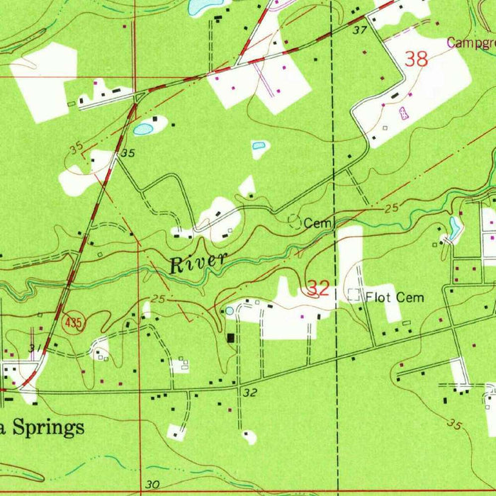
Published in 1980 from mapping dated 1968, “Covington” is a United States Geological Survey topographic portrait of southeastern Louisiana at the intimate 1:24,000 scale. Centered on Covington and nearby Abita Springs, the map captures a region where small-town streets, wooded tracts, river corridors, and emerging transportation routes meet on the north shore of Lake Pontchartrain. Its title is spare and official, in the USGS tradition, yet the sheet itself is richly informative: a carefully measured record of settlement, terrain, drainage, and infrastructure at a moment when the area was balancing rural character with modern suburban growth. For collectors, it offers both scientific precision and a quietly evocative view of St. Tammany Parish in the late twentieth century.
The map’s topographic language is classic USGS: contour lines articulate the subtle rise and fall of the land, while color coding distinguishes woodland, water, roads, built-up areas, and open ground. In a landscape without dramatic mountains, these contours become especially revealing, showing the rolling uplands and lower riverine zones that shape movement, settlement, and drainage around Covington. The Tchefuncte River and Little Tchefuncte River form natural anchors, their courses threading through the mapped area and giving structure to the surrounding roads and neighborhoods. The green tinting suggests the region’s lush vegetation, evoking piney woods, riparian corridors, and the humid natural richness that defines this part of Louisiana’s northshore.
Covington appears as the principal urban focus, its grid and connecting roads registering a community already well established by the late 1960s. Schools, civic sites, residential streets, and community facilities are embedded within the cartographic fabric, making the map a valuable record of everyday geography as much as physical terrain. U.S. Route 190 is a key artery, linking Covington to neighboring communities and broader regional traffic, while the later imprint date places the sheet within a period of accelerating development. The presence of Interstate 12 marks a transformative transportation corridor, one that would increasingly tie the north shore to Baton Rouge, Slidell, New Orleans, and the wider Gulf South.
Abita Springs, shown northeast of Covington, adds another layer of local history and atmosphere. Long associated with its mineral springs, health-resort reputation, and shaded small-town setting, Abita Springs stands in contrast to the more expansive road network around Covington. On this map, its placement among waterways, wooded areas, and connecting roads reveals how closely community identity in the region was bound to natural features. The relationship between the two towns is legible in the lines of travel between them, suggesting a network of local movement rather than isolated settlements. Parks, recreational spaces, trails, and residential pockets contribute to a picture of a landscape valued for both habitation and outdoor life.
As a historical document, this USGS sheet preserves a precise snapshot of land use and infrastructure before later decades of northshore expansion reshaped the area. Roads, neighborhoods, river crossings, and open tracts appear as they were recorded in the 1968 mapping, allowing modern viewers to trace change against a dependable federal survey. The United States Geological Survey brought to such maps a reputation for rigor, consistency, and understated graphic elegance, transforming field measurement and aerial interpretation into a readable civic and environmental record. “Covington” is therefore more than a utilitarian map: it is a finely organized witness to the interplay of water, woods, roads, and community in a distinctive Louisiana landscape.
Cities, towns and places on this map
- Covington
- Abita Springs
- Interstate 12
- Tchefuncte River
- Little Tchefuncte River
- U.S. Route 190
- Lake Pontchartrain
- Residential areas
- Parks and recreational spaces
- Schools and community facilities
- Roadways and trails
Historical context & cartographic details
- Produced by the United States Geological Survey (USGS), known for its detailed topographical mapping.
- Historical 1:24,000 topographical map of Covington, Abita Springs, and the surrounding area in Louisiana.
- Dated 1968, with a 1980 imprint.
- Shows landforms, water bodies, roads, urban layout, and human-made structures.
- Uses standard USGS topographical styling with color coding to distinguish terrain and landscape features.
- Includes contour lines showing elevation changes, rolling hills, and low-lying areas.
- Serves as a historical record of land use, development patterns, and infrastructure around Covington in the late 1960s.
Looking for a particular place? Review the detailed images to confirm that the town, landmark or feature you have in mind appears on the map. If you are unsure, ask our workshop to check before you order.
Detailed maps are especially rewarding at larger sizes, where names, boundaries and decorative features have more room to be appreciated. Use the close-up preview and size guide to choose the right scale for your wall.
This map looks amazing at sizes all the way up to 50in (125cm). If you are looking for a larger map, please get in touch.
The model in the listing images is holding the 16x20in (40x50cm) version of this map.
Where personalisation is available, you can add a short title or dedication, mark one meaningful place, or request one considered visual detail. See personalised map examples.
Every piece is printed to museum-grade archival standards using fade-resistant pigment inks on acid-free matte paper. Choose an unframed map print, framed map or canvas using the finish options above. Framed maps use crystal-clear optical acrylic and arrive ready to hang.
With its rich detail and strong sense of place, this map makes a considered gift for a new home, anniversary, retirement or anyone with a personal connection to the area shown. Still deciding? Explore our collection of rare old and vintage maps to discover another place, period or style.
Share