The Unique Maps Co.
Old Map of Lexington, Kentucky by USGS, 1952 – Coletown, Kentucky River & Red River
Old Map of Lexington, Kentucky by USGS, 1952 – Coletown, Kentucky River & Red River
Couldn't load pickup availability
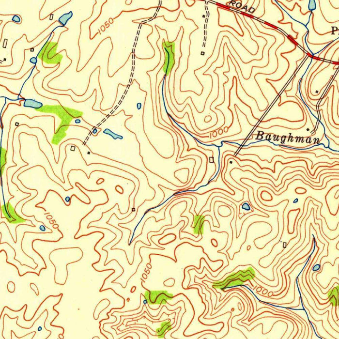
Published in 1953 from 1952 mapping, the USGS quadrangle titled “Coletown” captures a revealing mid-century portrait of Lexington, Kentucky, and its surrounding Bluegrass country. At a scale of 1:24,000, it belongs to the United States Geological Survey’s classic series of detailed topographic maps, designed to translate landscape into a precise language of contours, waterways, roads, railways, and settlement. Lexington appears within a broader terrain of farms, small communities, valleys, and wooded stream corridors, its urban footprint still far more compact than it would become in later decades. The result is both a technical document and a historical snapshot, preserving the geography of a region on the cusp of postwar expansion.
The United States Geological Survey, established in 1879, brought scientific rigor and national ambition to American mapmaking. Its topographic quadrangles were created not merely for navigation, but for understanding land itself: elevation, drainage, settlement, transport, and natural resources. In “Coletown,” that disciplined approach is evident in the careful contour work, the exact placement of roads and rail lines, and the close attention paid to rivers, tributaries, and rural infrastructure. The map reflects the USGS’s broader mission to make the American landscape measurable and legible, supporting everything from engineering and agriculture to conservation and urban planning. Its understated style is part of its authority, presenting the land with clarity, precision, and quiet elegance.
Lexington’s presence gives the map a particularly rich cultural resonance. Known as the “Horse Capital of the World,” the city sits in the famed Bluegrass region, where limestone-rich soils and gently rolling pasturelands helped foster one of America’s great equine landscapes. The surrounding agricultural areas shown here evoke a world of horse farms, crop fields, rural lanes, and dispersed settlements, with Coletown and nearby communities woven into the region’s working countryside. The map predates much of Lexington’s later suburban spread, allowing today’s viewer to see the city before highways, subdivisions, and commercial corridors transformed its edges. It is a cartographic record of a landscape still strongly shaped by agriculture, topography, and local roads.
The physical character of the region is beautifully expressed through the map’s classic topographic language. Contour lines trace the rise and fall of rolling hills, while valleys and stream courses cut fine patterns across the sheet. The Red River, Kentucky River, local tributaries, and smaller waterways reveal the drainage structure of the Bluegrass landscape, linking uplands, hollows, and bottomlands into a coherent natural system. Lakes, parks, natural reserves, and wooded areas add further texture, suggesting places where land use, recreation, and environmental character intersect. The terrain is not dramatic in an alpine sense, but its subtlety is precisely what makes the map compelling: every curve of elevation speaks to the region’s geology, farming history, and settlement patterns.
As a historical document, “Coletown” is especially valuable because it preserves a Lexington-area landscape before the full force of late twentieth-century development. Since the early 1950s, the region has seen significant urban growth, changing transportation networks, altered land use, and increasing pressure on agricultural and natural spaces. Roads and railways shown on the map mark the infrastructure of an earlier era, while the distribution of farms, valleys, and small settlements offers a baseline for understanding environmental and urban change. For collectors, historians, planners, and anyone drawn to Kentucky’s Bluegrass identity, this map offers more than place names and contour lines. It reveals a living landscape at a particular moment in time, poised between rural inheritance and modern transformation.
Cities, towns and places on this map
- Lexington, KY
- Coletown, KY
- Red River
- Kentucky River
- Lakes
- Various roads and railways
- Parks and natural reserves
- Contour lines indicating elevation
- Valleys and hills
- Agricultural areas
- Rivers and tributaries surrounding Lexington
- Notable landmarks within the area
Historical context & cartographic details
- Historical 1:24,000 topographical map produced by the United States Geological Survey.
- Created in 1952 and published with a 1953 imprint.
- Shows Lexington, Kentucky and the surrounding Bluegrass region.
- The USGS, established in 1879, is known for its extensive scientific mapping and geological studies.
- Uses a classic topographic style, including contour lines and shaded relief to represent terrain and elevation.
- Captures rolling hills and valleys characteristic of the Lexington area.
- Provides a valuable historical reference for understanding changes in urban growth, land use, and the local environment since the early 1950s.
Looking for a particular place? Review the detailed images to confirm that the town, landmark or feature you have in mind appears on the map. If you are unsure, ask our workshop to check before you order.
Detailed maps are especially rewarding at larger sizes, where names, boundaries and decorative features have more room to be appreciated. Use the close-up preview and size guide to choose the right scale for your wall.
This map looks amazing at sizes all the way up to 50in (125cm). If you are looking for a larger map, please get in touch.
The model in the listing images is holding the 16x20in (40x50cm) version of this map.
Where personalisation is available, you can add a short title or dedication, mark one meaningful place, or request one considered visual detail. See personalised map examples.
Every piece is printed to museum-grade archival standards using fade-resistant pigment inks on acid-free matte paper. Choose an unframed map print, framed map or canvas using the finish options above. Framed maps use crystal-clear optical acrylic and arrive ready to hang.
With its rich detail and strong sense of place, this map makes a considered gift for a new home, anniversary, retirement or anyone with a personal connection to the area shown. Still deciding? Explore our collection of rare old and vintage maps to discover another place, period or style.
Share