The Unique Maps Co.
Old Map of Midway, Kentucky by USGS, 1941 – Kentucky River & Ekron
Old Map of Midway, Kentucky by USGS, 1941 – Kentucky River & Ekron
Couldn't load pickup availability
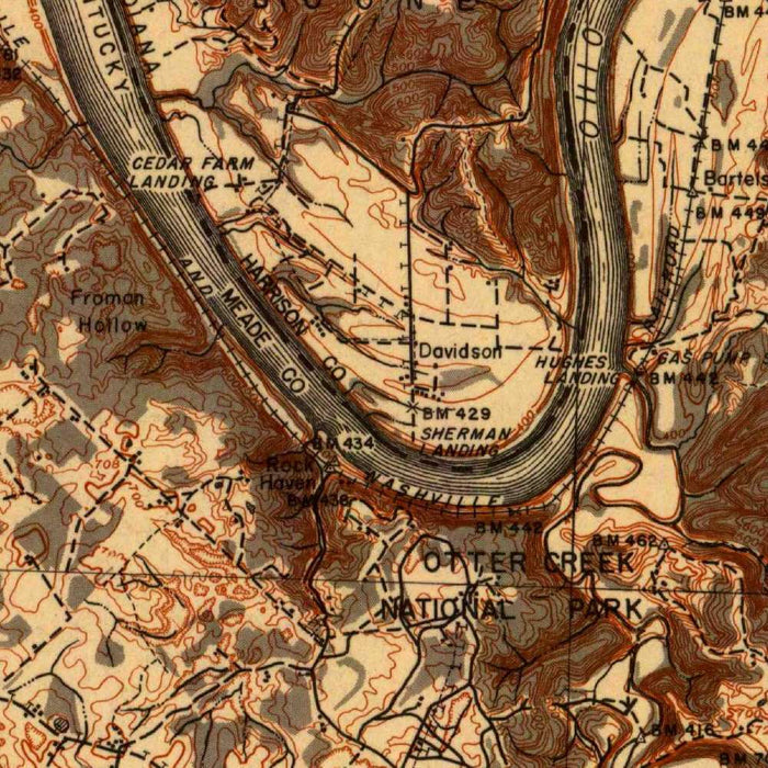
The US Geological Survey’s topographical map titled “Ekron” presents Midway, Kentucky, and its surrounding countryside as surveyed in 1941, at a moment when the United States stood on the threshold of World War II. Drawn at the detailed 1:62,500 scale, it captures a landscape of small towns, roads, railways, river corridors, and rolling uplands with the disciplined clarity characteristic of federal cartography. The original title is spare and evocative, naming the quadrangle while allowing the map itself to reveal the richness of the terrain. Brown contour lines rise and fall across the sheet, giving the land an almost sculptural quality and allowing the viewer to read hills, valleys, ridges, and drainage patterns with remarkable immediacy.
The US Geological Survey, founded in 1879, became one of the great cartographic institutions of the modern world, charged with measuring and describing the American landscape with scientific precision. By the early twentieth century, its topographic sheets had become indispensable tools for engineers, planners, military authorities, geologists, farmers, and travelers. This map reflects that tradition: restrained, exacting, and deeply informative. Its visual language is both practical and elegant, using contour intervals, color coding, hydrographic markings, and transportation symbols to organize the land into a readable system. The result is not merely a navigational document, but a portrait of Kentucky as understood through the era’s most advanced surveying standards.
Midway appears as the principal populated place within the map’s field of interest, set amid the roads, railways, and rural settlement patterns that shaped central Kentucky life. The town’s name evokes its historic role as a railway community, and the surrounding transport network speaks to the importance of rail lines and country roads in linking farms, markets, and neighboring settlements. The map’s infrastructure is especially revealing: routes thread through the valleys and across gentler grades, while railways follow practical corridors through the terrain. In this way, the sheet records not only where people lived, but how they moved, traded, and connected with the broader region.
Natural features give the map much of its visual drama. Portions of the Kentucky River and associated waterways articulate the landscape, their courses cutting through hills and shaping valleys over long periods of geological time. The contour lines cluster and spread in rhythmic patterns, making elevation changes immediately legible and creating a striking three-dimensional impression. Hills, hollows, and drainage basins emerge with particular force, showing how water and terrain dictated the placement of roads, farms, and settlements. This emphasis on landform is one of the great pleasures of USGS mapping: the viewer can move imaginatively across the country, sensing rises, descents, and river crossings from the page alone.
As a 1941 survey, “Ekron” preserves a significant historical moment in Kentucky’s geographic and infrastructural development. It depicts an area before the vast postwar transformations of highway expansion, suburban growth, and modern land-use change had fully reshaped the American landscape. The map belongs to an era when topographic knowledge held particular strategic value, as the nation prepared for wartime mobilization and required accurate information about terrain, transportation, and settlement. Yet its appeal extends beyond utility. It is a beautifully ordered record of place: a measured depiction of Midway and its environs, where the geometry of roads and railways meets the older, more sinuous forms of river, ridge, and valley.
Cities, towns and places on this map
- Midway, Kentucky
- Portions of the Kentucky River
- Various roads and railways surrounding Midway
- Nearby hills and valleys
- Other small towns and populated areas in the vicinity
Historical context & cartographic details
- Historical 1:62,500 topographical map titled “Ekron”, produced by the US Geological Survey.
- Shows Midway, Kentucky, and the surrounding area as surveyed in 1941.
- The US Geological Survey is a U.S. government scientific agency known for geospatial data and cartography.
- Uses brown contour lines and color shading to show elevation changes and topographic relief.
- Depicts hills, valleys, waterways, roads, railways, and other natural and built features.
- Reflects early 20th-century USGS mapping style and cartographic design.
- Captures the area’s geographic and infrastructural character as the United States was approaching World War II.
Looking for a particular place? Review the detailed images to confirm that the town, landmark or feature you have in mind appears on the map. If you are unsure, ask our workshop to check before you order.
Detailed maps are especially rewarding at larger sizes, where names, boundaries and decorative features have more room to be appreciated. Use the close-up preview and size guide to choose the right scale for your wall.
This map looks amazing at sizes all the way up to 50in (125cm). If you are looking for a larger map, please get in touch.
The model in the listing images is holding the 16x20in (40x50cm) version of this map.
Where personalisation is available, you can add a short title or dedication, mark one meaningful place, or request one considered visual detail. See personalised map examples.
Every piece is printed to museum-grade archival standards using fade-resistant pigment inks on acid-free matte paper. Choose an unframed map print, framed map or canvas using the finish options above. Framed maps use crystal-clear optical acrylic and arrive ready to hang.
With its rich detail and strong sense of place, this map makes a considered gift for a new home, anniversary, retirement or anyone with a personal connection to the area shown. Still deciding? Explore our collection of rare old and vintage maps to discover another place, period or style.
Share