The Unique Maps Co.
Old Map of Newfoundland by Arrowsmith, 1884: St. John's, Great Bank, Trinity Bay, Rivers, Electoral Districts
Old Map of Newfoundland by Arrowsmith, 1884: St. John's, Great Bank, Trinity Bay, Rivers, Electoral Districts
Couldn't load pickup availability
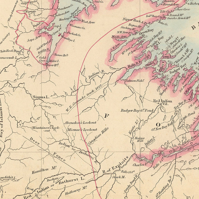
The Island of Newfoundland map, crafted by the esteemed cartographer John Arrowsmith in 1884, is a remarkable testament to the art and science of mapmaking in the late 19th century. This hand-colored masterpiece originates from Stanford's London Atlas Of Universal Geography, a prestigious collection known for its detailed depiction of global political and physical divisions. The map not only highlights the electoral districts of Newfoundland but also elegantly showcases the island's intricate geography, from its rugged coastlines to its sprawling rivers, all set against the Prime Meridian at Greenwich.
John Arrowsmith, a luminary in the field of cartography, was renowned for his meticulous attention to detail and innovative approach to mapmaking. His collaboration with Edward Stanford Ltd. resulted in an atlas that expanded the boundaries of geographic knowledge at the time. The map of Newfoundland is a prime example of this collaboration, reflecting the rich cartographic history and the evolving understanding of the world during that era. Arrowsmith's legacy is evident in the precision and artistry of this map, making it a coveted piece for collectors and history enthusiasts alike.
The design of the map is both functional and aesthetically pleasing, with hand-colored details that bring the political and physical features of Newfoundland to life. Electoral districts are clearly marked, providing insight into the political landscape of the time. The map also features notable geographical elements such as the Great Bank of Newfoundland, and bays like Trinity Bay and the Bay of Islands, which are crucial to understanding the island's natural environment and maritime history.
Newfoundland's towns and cities, including St. John's, Harbour Grace, and Bonavista, are prominently displayed, offering a glimpse into the island's human geography. These settlements, some of which remain significant today, are depicted with precision, reflecting their importance in the region's history and development. The map also captures the island's rivers and inlets, highlighting the vital waterways that have shaped Newfoundland's economy and culture over the centuries.
This map is not just a geographical document; it is a window into the past, revealing the historical context and significance of Newfoundland during a pivotal time in its history. The combination of political, physical, and cultural elements makes this map an invaluable resource for understanding the island's legacy. Its exquisite design and historical depth make it a standout piece in any collection, embodying the elegance and expertise of 19th-century cartography.
Cities and towns on this map
- St. John's
- Harbour Grace
- Carbonear
- Bonavista
- Twillingate
- Fogo
- Trinity
- Placentia
- Ferryland
- Burin
- Fortune
Notable Features & Landmarks
- Electoral districts: Clearly marked, highlighting political divisions.
- Rivers: Several rivers are labeled, indicating important waterways.
- Bays: Notable bays such as Bay of Islands and Trinity Bay are marked.
- Banks: Features like the Great Bank of Newfoundland are shown.
- Geographical features: Includes inlets and coastal features.
Historical and design context
- Name of the map: The Island of Newfoundland
- Date created: 1884
- Mapmaker/Publisher: John Arrowsmith, with publication by Edward Stanford Ltd.
- Historical significance: Part of Stanford's London Atlas Of Universal Geography, showcasing political and physical divisions globally.
- Design style: Hand-colored, folded map highlighting electoral districts, cities, towns, and rivers.
- Prime Meridian: Set at Greenwich.
- Collection context: Originates from a renowned atlas collection, expanded from John Arrowsmith's original set.
- Atlas details: Partial folio edition believed to be part of a special limited release in 1884.
Please double check the images to make sure that a specific town or place is shown on this map. You can also get in touch and ask us to check the map for you.
This map looks great at every size, but I always recommend going for a larger size if you have space. That way you can easily make out all of the details.
This map looks amazing at sizes all the way up to 100in (250cm). If you are looking for a larger map, please get in touch.
Please note: the labels on this map are hard to read if you order a map that is 16in (40cm) or smaller. The map is still very attractive, but if you would like to read the map easily, please buy a larger size.
The model in the listing images is holding the 16x20in (40x50cm) version of this map.
The fifth listing image shows an example of my map personalisation service.
If you’re looking for something slightly different, check out my collection of the best old maps to see if something else catches your eye.
Please contact me to check if a certain location, landmark or feature is shown on this map.
This would make a wonderful birthday, Christmas, Father's Day, work leaving, anniversary or housewarming gift for someone from the areas covered by this map.
This map is available as a giclée print on acid free archival matte paper, or you can buy it framed. The frame is a nice, simple black frame that suits most aesthetics. Please get in touch if you'd like a different frame colour or material. My frames are glazed with super-clear museum-grade acrylic (perspex/acrylite), which is significantly less reflective than glass, safer, and will always arrive in perfect condition.
Share