The Unique Maps Co.
Old Map of Ukraine "Land of the Cossacks", 1943: Kyiv, Black Sea, Carpathians
Old Map of Ukraine "Land of the Cossacks", 1943: Kyiv, Black Sea, Carpathians
Couldn't load pickup availability
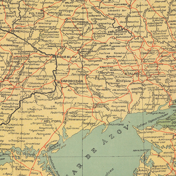
The map titled "Ukraina, Tierras Cossacas," crafted by B. Mylinsky in 1943, offers a fascinating glimpse into a pivotal moment in history. Created during the tumultuous years of World War II, this map was produced by Ukrainian nationalists residing in Argentina, a hub for the Ukrainian diaspora. It reflects a vision of Ukraine with expanded borders, capturing territories that were historically significant to the community. This map not only serves as a geographical guide but also as a testament to the cultural and political aspirations of Ukrainians during a time of global upheaval.
The map is a vibrant tapestry of political divisions, major cities, and natural features, meticulously detailed to reflect the era's geopolitical landscape. It includes parts of Poland, Belarus, Russia, Moldova, and Transnistria, regions that were historically intertwined with Ukraine. This expanded view highlights the complex history and cultural ties that have shaped Eastern Europe. The inclusion of Cossack republics in southern Russia adds another layer of historical intrigue, referencing territories that claimed autonomy during the Russian Civil War.
Cities such as Kyiv, Kharkiv, and Odesa are prominently featured, serving as key cultural and economic centers. The map's detailed depiction of these cities, along with others like Lviv and Dnipro, provides insight into the urban landscape of the time. The inclusion of towns from neighboring countries, such as Przemyśl and Chelm in Poland, and Gomel in Belarus, further emphasizes the interconnectedness of the region. Each city and town is a marker of historical significance, contributing to the rich tapestry of Eastern European history.
Natural features are elegantly portrayed, with the Black Sea and Sea of Azov providing a striking backdrop to the southern regions. The relief shading highlights the mountainous terrains of the Carpathians and the Caucasus, adding depth and dimension to the map. These geographical features not only define the physical landscape but also play a crucial role in the historical narratives of the region. The map's attention to natural resources, such as fuel and mineral deposits, underscores the economic importance of these areas.
B. Mylinsky's map is more than just a cartographic achievement; it is a window into the past, reflecting the hopes and dreams of a nation during a time of conflict. It captures the essence of a land rich in history, culture, and natural beauty. This map is a collector's treasure, offering a unique perspective on Ukraine and its neighbors, and serving as a poignant reminder of the enduring spirit of its people.
Cities and towns on this map
- Ukraine:
- Kyiv
- Kharkiv
- Odesa
- Dnipro
- Lviv
- Zaporizhzhia
- Kryvyi Rih
- Mykolaiv
- Mariupol
-
Vinnytsia
-
Poland (historical context):
- Przemyśl
-
Chelm
-
Belarus (historical context):
-
Gomel
-
Russia (historical context):
- Belgorod
-
Starodub
-
Moldova:
-
Chișinău
-
Transnistria:
- Tiraspol
Notable Features & Landmarks
- Inset maps:
- Natural fuel deposits
- Distribution of Ukrainian population in Eastern Europe
- Time zones
-
Mineral deposits
-
Bodies of water:
- Black Sea (Mar Negro)
-
Sea of Azov
-
Mountains: Relief shown in areas like the Carpathians and the Caucasus.
-
Borders: Expanded borders of Ukraine including regions from neighboring countries.
Historical and design context
- Mapmaker/Publisher: B. Mylinsky
- Date of creation: 1943
- Historical context: Created during WWII by Ukrainian nationalists in Argentina.
- Political context: Shows Ukraine with expanded borders, historically justified by the community.
- Cossack Republics: Marks regions in southern Russia as different Cossack republics, reflecting territories that claimed existence during the Russian Civil War (1918-1922).
- Design/Style: Color map with relief shown by shading, includes detailed political divisions and natural resources.
Please double check the images to make sure that a specific town or place is shown on this map. You can also get in touch and ask us to check the map for you.
This map looks great at every size, but I always recommend going for a larger size if you have space. That way you can easily make out all of the details.
This map looks amazing at sizes all the way up to 100in (250cm). If you are looking for a larger map, please get in touch.
Please note: the labels on this map are hard to read if you order a map that is 20in (50cm) or smaller. The map is still very attractive, but if you would like to read the map easily, please buy a larger size.
The model in the listing images is holding the 18x24in (45x60cm) version of this map.
The fifth listing image shows an example of my map personalisation service.
If you’re looking for something slightly different, check out my collection of the best old maps to see if something else catches your eye.
Please contact me to check if a certain location, landmark or feature is shown on this map.
This would make a wonderful birthday, Christmas, Father's Day, work leaving, anniversary or housewarming gift for someone from the areas covered by this map.
This map is available as a giclée print on acid free archival matte paper, or you can buy it framed. The frame is a nice, simple black frame that suits most aesthetics. Please get in touch if you'd like a different frame colour or material. My frames are glazed with super-clear museum-grade acrylic (perspex/acrylite), which is significantly less reflective than glass, safer, and will always arrive in perfect condition.
Share